Plate Tectonics
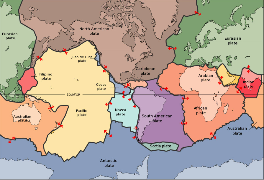
"Plate tectonics is a theory that says the lithosphere, Earth’s outermost layer, is broken into large sections, or plates, that move around on top of the asthenosphere, the layer below the lithosphere, due to convection currents. There are three ways these plates can interact at there boundaries: they can push together at convergent boundaries, pull apart at divergent boundaries, or grind past each other at transform boundaries. Evidence for this theory is abundant. Long, long ago, in the 20th century, people noticed a few things about the continents. They noticed that the edges of continents seem to have once fitted together. They also found fossils of the same animals on continents separated by oceans, animals that could have in no way crossed these oceans. How is this possible, you ask? Well, a theory called continental drift was proposed: this theory said the continents had not always been where they are today, that they had once been merged together in what was known as a supercontinent. This way, animals could have freely walked on whatever land they pleased. Now I know what you’re thinking. You’re thinking “But this still doesn't explain everything! If the continents were once together, how did they grow apart?". At first, scientists were stumped, but that’s where plate tectonics comes in. When the theory of plate tectonics was proposed, these scientists finally had the mechanism they were looking for. Other evidence includes magnetism at mid-ocean ridges and seafloor spreading. If you don’t know, a mid-ocean ridge is an underwater mountain range. Some rocks at these mid-ocean ridges contain minerals that lock-in a record of the direction and intensity of the magnetic field when they form. Back in the 1950s, scientists noticed a zebra-like pattern in these rocks. One stripe of rocks had normal polarity, the next had reverse polarity, and so on. The pattern was the same on both sides of the ridge. When scientists realized this, they wondered what you’re probably wondering now: How had this happened, and how did mid-ocean ridges form in the first place? It was determined that a process called seafloor spreading occurs. Seafloor spreading takes place at divergent plate boundaries. As the plates diverge, magma rises up to fill the cracks that are formed and cools. If you want to know how scientists discovered this process, watch on. The first evidence we have is heat flow data. Heat flow data was collected on and around mid-ocean ridges, and it was discovered that heat flow values were generally greater close to the mid-ocean ridge rather than far away. This supports the theory of seafloor spreading, as the crust at a mid ocean ridge is newly formed from hot magma, while the crust away from them is old and cold. You may be wondering where all this old, cold crust goes. Well, this crust eventually crosses the ocean, where it comes to a convergent boundary. Here, the dense oceanic plate subducts under the continental plate. This forms an ocean trench and keeps the Earth’s surface area the same. Also, when the plate subducts into the hot mantle, it starts melting, causing magma to rise to the surface. This magma breaks through the continental crust to form island arcs and volcanoes. Moving on, another piece of evidence involves hot spots and island chains. A hot spot is a volcanic region fed large amounts of magma from the mantle. Archipelagos, or island chains, form above hot spots. It has been shown that the islands in these archipelagos are generally ordered by increasing age, which can be explained by plate tectonics like this: magma comes up to form an island, the plate moves, and the process repeats. All this evidence supports the theory of plate tectonics. To put it simply, mid-ocean ridges, ocean trenches, and the rest would not exist without plate tectonics. Now that you understand plate tectonics, you should understand can cause events such as earthquakes, volcanoes, and tsunamis. Today, we’ll be focusing on earthquakes. An earthquake is the result of a sudden release of energy in the Earth's crust that creates seismic waves. The magnitude of an earthquake is a number that represents the size of the earthquake. Earthquake magnitudes can be measured with a device called a seismograph and can range from too low to be felt, to high enough to destroy cities. Earthquakes are caused mostly by rupture of geological faults, generally along plate boundaries. A fault is a planar fracture or discontinuity in a volume of rock, across which there has been significant displacement along the fractures as a result of earth movement. There are three types of faults: thrust faults, normal faults, and strike-slip faults. Thrust faults occur mainly at divergent boundaries, normal faults at convergent boundaries, and strike-slip faults at transform boundaries. An earthquake's point of initial rupture is called its focus or hypocenter. The epicenter is the point at ground level directly above the hypocenter. Next, you should know what foreshocks and aftershocks are. A foreshock is a smaller earthquake that occurs before the main one, while an aftershock is a smaller earthquake that occurs after the main one. The designation of an earthquake as foreshock, mainshock or aftershock is only possible after the event and if an aftershock is bigger than the mainshock, it is redesignated as the mainshock."
- Narrator in The Kobe Earthquake
